
A consumer gaming company just told the world it quietly assembled billions of images, captured by mobile game players over the past decade, into a visual positioning model. That model can now pinpoint a device's location to within centimeters using camera imagery alone. Delivery robots are the first application. MIT Technology Review broke the exclusive. Popular Science, Slashdot, and dozens of other outlets picked it up.
VPS is finally in the mainstream conversation. Good.
Visual positioning systems are not an AR novelty. They are spatial infrastructure. Every robot, headset, phone, drone, and AI agent that needs to know where it is inside a physical space will eventually depend on some form of VPS. The technology enables centimeter-level 6DoF localization without GPS, without beacons, without markers. A camera captures what it sees, matches it against a 3D map, and returns an exact position and orientation. That is a platform-level capability, not a feature checkbox.
So the validation is overdue. And it is welcome.
But the model behind those headlines was not built for enterprise. Our customers and pilots which include Fortune 500 companies tell us this directly. The reasons they choose MultiSet over other VPS options, including crowdsourced approaches, map to seven specific gaps in the consumer model. These are not hypothetical objections. They are the reasons contracts get signed.
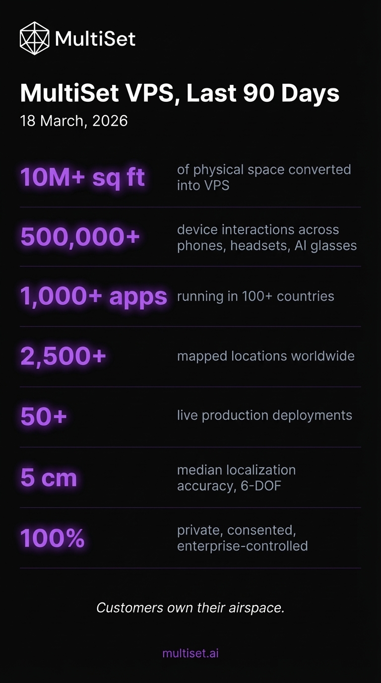
| 10M+ sq ft | of physical space converted into VPS for AI to query and position devices |
| 500,000+ | device interactions across phones, XR headsets, and AI glasses |
| 1,000+ apps | running in 100+ countries |
| 2,500+ | mapped locations |
| 50+ | live production deployments |
| 5 cm | median localization accuracy, 6-DOF |
| 100% | private, consented, enterprise-controlled environments |
Dozens of additional self-hosted deployments run entirely within client infrastructure. MultiSet never sees that data, never monetizes it, never harvests it. Customers own their airspace.
Seven Gaps Between Consumer VPS and Enterprise Reality
1. The consent model is under fire
Hundreds of millions of people contributed spatial data while playing a mobile game. The company describes this as voluntary, opt-in scanning. The public disagrees. The social media reaction was immediate and unambiguous: people believed they were playing a game, not building one of the largest visual datasets in AI history. That data has since been spun into a separate AI company, placed under new ownership, and commercialized for robotics and enterprise navigation.
The legal debate around whether original terms of service covered this use could drag on for years. The enterprise question is simpler. If a VPS vendor built its foundational dataset through a consent model that is now under public scrutiny, what does that reveal about how the vendor thinks about data governance? And if their model depends on aggregating spatial data from external sources, what stops your data from receiving the same treatment?
MultiSet does not train its models on customer data. We train individual models finetuned to each customer's specific environment. Your factory floor gets a model optimized for your factory floor. Your hospital wing gets a model tuned to your hospital wing. That spatial data never enters a shared model. It never trains anything for another customer. It is never commercialized.
Our baseline model delivers industry-leading accuracy before any finetuning. The AREA's independent evaluation of six global VPS vendors named MultiSet the most robust solution, giving it perfect scores in environmental resilience, map-to-map navigation, and developer support. Per-environment finetuning takes what is already strong and makes it specific to your space.
2. Coverage clusters around gaming hot spots, not real operations
The consumer dataset is not a map of the world. It is a map of places where gamers went.
Coverage concentrates around in-game points of interest: public parks, statues, monuments, murals, and storefronts that served as virtual battle arenas and collection points. Major cities with large player populations have dense data. Everywhere else has gaps. Or nothing.
Enterprise VPS does not get deployed at public fountains. It runs on manufacturing floors, inside distribution centers, across hospital complexes, on construction sites, inside energy facilities, and throughout airport terminals. These are private, restricted spaces. No consumer gaming dataset covers them, and no amount of crowdsourcing will fix that. You cannot build a visual positioning system for a pharmaceutical cleanroom by hoping gamers walk through.
Enterprise VPS starts with the environment you operate in and maps from there. MultiSet customers capture their own spaces, with their own tools, at whatever coverage density their operation requires. No dependence on external data sources. No coverage lottery.
3. Outdoor urban positioning is a fraction of the enterprise VPS picture
The consumer VPS story centers on city streets, sidewalk navigation, and GPS drift between tall buildings. Real problem for delivery robots. Narrow slice of enterprise reality.
Most high-value enterprise positioning happens indoors. Factory floors with heavy machinery. Multi-story hospitals where every corridor looks identical. Underground utilities. Warehouses running 24/7 in shifting light. Hangars. Server rooms. Retail locations that need consistent indoor localization across hundreds of sites.
MultiSet handles indoor and outdoor environments, multi-floor navigation through MapSet stitching, and spaces from a single bay to over 100,000 square meters. The on-device engine runs with zero network connectivity, delivering 5 cm median accuracy and 6-DOF localization with look-up times of 52 ms on Snapdragon 8 Gen 3 and 38 ms on Apple Silicon.
4. The data pipeline is shrinking
The consumer dataset peaked when the game peaked. Roughly 230 million monthly players in 2016. Current estimates sit around 50 million, trending down. New scans are slowing. Temporal coverage of evolving environments is thinning. The locations that are well-mapped are the locations that were popular years ago, not necessarily the locations that need accurate positioning today.
Physical environments change. Construction, renovation, equipment reconfiguration, seasonal shifts. A dataset built on historical gaming activity does not refresh itself.
Enterprise VPS runs on purpose-captured scans of specific spaces, refreshed by the teams that operate those spaces. MultiSet's re-mapping workflow lets organizations update maps as facilities evolve. The data stays current because the people who depend on accurate positioning keep it current.
5. Enterprise security and deployment flexibility are missing
The people who built the consumer VPS designed it for a public-facing gaming application. Private cloud deployment, self-hosted on-prem operation, on-device offline mode, air-gapped environments: nobody built any of that into the architecture. For organizations in defense, healthcare, critical infrastructure, or regulated industries, the absence is a disqualifier.
MultiSet supports public cloud, private cloud, self-hosted on-premises, and fully on-device deployment. AES-256 at rest. TLS 1.3 in transit. ISO 27001 and SOC 2 aligned. For self-hosted customers, every map, every API call, every spatial query stays inside client infrastructure. We never touch it.
A 3D spatial map of your facility reveals production layout, equipment placement, workflow patterns, and operational capacity. In many industries, that information is regulated. The VPS platform you choose becomes a link in your data supply chain. Choose accordingly.
6. Proprietary capture creates lock-in
The vendor built the consumer VPS through a proprietary data pipeline: specific apps, specific devices, specific capture workflows they controlled entirely. That works when hundreds of millions of users generate data for free. It does not work when you already own scanning hardware and have established capture workflows.
Most organizations evaluating VPS already have 3D capture tools. Matterport. NavVis. Leica. FARO. iPhone LiDAR. CAD/BIM models. E57 point clouds. A scan-agnostic VPS platform should ingest what you already have, not force you to start over.
MultiSet imports Matterport MatterPaks, NavVis and Leica data through E57, iPhone LiDAR scans, and CAD/BIM files. Mix sources within one environment using MapSet stitching. One customer recently built a 25,000 square meter VPS with nothing but an iPhone and our MapFoundry tool. Same 5 cm median accuracy. No proprietary capture dependency.
7. The ownership structure raises questions
This angle has received almost no coverage, and it should.
The gaming division that collected the original spatial dataset was acquired by a company backed by a foreign sovereign wealth fund. The AI spinout that retained the VPS technology and mapping data is separately capitalized but shares investors with the acquiring entity. For enterprise buyers in defense, government, critical infrastructure, or any sector with supply-chain security requirements, the question of who controls the spatial intelligence platform, and under what jurisdiction, is a procurement issue. Compliance teams will flag it.
Enterprise spatial data regularly intersects with national security interests, export controls, and data residency mandates. Understanding the ownership structure, data jurisdiction, and corporate governance behind a VPS vendor is standard practice.
MultiSet is independently owned. Customer spatial data is governed by clear contractual terms and stored in customer-specified jurisdictions. For self-hosted deployments, data never leaves client infrastructure. No shared pool. No ambiguity about control.
What Enterprise VPS Looks Like When It Is Built Right
The seven points above are not our market analysis. They are customer feedback, repeated in nearly every enterprise VPS evaluation we participate in. Here is what those customers get when they choose MultiSet.
A model trained for your environment, not the world's
Instead of one massive model trained on billions of random images and asked to generalize, MultiSet trains individual models finetuned to each customer's specific space. Your warehouse gets a model optimized for your warehouse. The VPS learns your lighting, your materials, your geometry, your visual characteristics.
Higher accuracy. Lower drift. More reliable localization under actual operating conditions.
The baseline model already delivers industry-leading performance out of the box. Environment-specific training makes it precise for your context.
One VPS across every device
A typical MultiSet deployment puts AR navigation on an iPhone, hands-free overlays on a Meta Quest, autonomous positioning on a mobile robot, and browser-based visualization on a supervisor's laptop. All in the same facility. All localizing against the same map. All at 5 cm median accuracy.
Native iOS and Android SDKs. Unity. Meta Quest. WebXR for browser AR with no app install. ROS 2 for robotics. Every device shares one coordinate system.
Ship fast
First localized scene in minutes. Expand by stitching scans into MapSets for multi-building, multi-floor continuity. Free sandbox tier to prototype. Production pricing scales by maps, API calls, and coverage area. Optional SLAs for private cloud and on-device.
The AREA gave MultiSet top marks for documentation and responsiveness. Support replies in hours, not days.
The Enterprise VPS Evaluation Checklist
Run every VPS vendor through these:
- Does the vendor aggregate your spatial data into a shared model or use it to train models for other customers?
- Is the VPS model trained on your environment, or on a generic dataset that may not represent your facility?
- How was the foundational dataset captured? Purpose-built, or derived from consumer activity whose commercial use is now contested?
- Can you bring existing capture tools (LiDAR, Matterport, NavVis, Leica, E57, CAD/BIM), or are you locked into proprietary capture?
- Does the VPS work indoors, outdoors, multi-floor, in variable lighting, at 10,000+ square meter scale?
- Can it localize with zero GPS and zero network connectivity?
- What is the proven median accuracy? Has an independent body validated it in real enterprise environments?
- Does it support iOS, Android, XR headsets, WebXR, and ROS on the same map?
- ISO 27001? SOC 2? Air-gapped deployment?
- Who owns the vendor? Where does your data reside? What jurisdiction governs it?
Own Your Airspace
VPS deserved its mainstream moment. The more people understand what visual positioning can do, the faster it becomes standard spatial infrastructure.
But the mainstream story does not address what enterprises actually need. Enterprises need spatial data they control. Environments they captured themselves. Models trained for their specific facilities. Deployments running on their own infrastructure. Accuracy they can verify independently. And a platform that treats their spatial data as their property, not as training material for a shared model or a commercialized dataset.
The question was never whether someone could crowdsource a map of the world.
It was whether you can build the world's most robust private VPS, running in your own cloud, for your own environments, under your own control.
We built MultiSet to answer that question.