Vuforia Alternative: Modern, Scan-Agnostic VPS + Object Tracking

Reboot your roadmap with MultiSet’s enterprise-ready Visual Positioning  System, including MapSet & ModelSet — the drop-in replacement for  Vuforia Advanced Model Targets & Area Targets. Detect any CAD-based  object from every angle with zero cloud training. Sub-10 cm accuracy,  private & on-prem deployments, zero legacy baggage.

Why Replace Vuforia in 2025?

Reuse existing scans: Import Matterport MatterPak and .E57 point clouds; preserve coordinate systems.
Multi‑map scale: Seamlessly localize across multi‑floor and campus‑scale spaces with Map Sets.
Enterprise deployment: Public cloud, private cloud/VPC, or on‑prem self‑hosting.
Occlusion‑ready: Use map meshes for accurate AR occlusion (per‑map and MapSet aware).
Cross‑platform: Unity/AR Foundation, native iOS/Android, WebXR, and Quest via Unity.
Area Tracking & Object Tracking in One SDK
CAPABILITY
VUFORIA AREA TARGETS
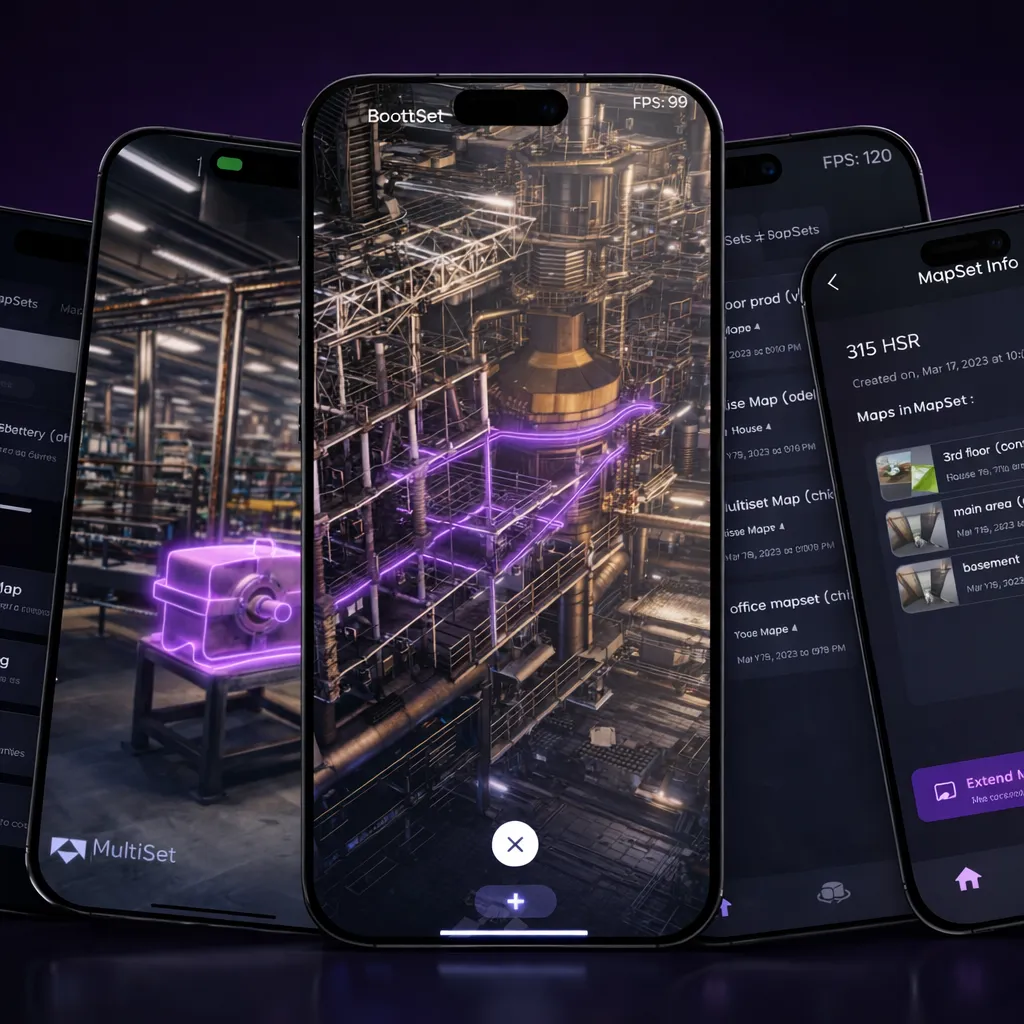
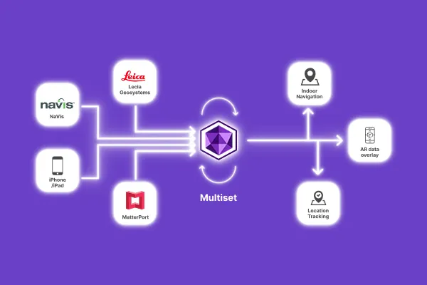
MULTISET VPS
Runtime Approach
Packaged datasets in‑app
Client‑SDK + server VPS for low‑latency localization
Multi‑space coverage
Multiple Area Targets can be combined with drift between targets
Native MapSet with stitching & seamless transitions across floors/areas
Occlusion
ATG exports meshes for occlusion
Map mesh–based occlusion
Coordinate preservation
Tied to generated dataset
Preserves source scan coordinates
Deployment options
App‑embedded datasets
Cloud/VPC/ on‑prem self‑hosting with enterprise controls
Web support
Vuforia Engine is native/mobile
WebXR & App Clips
Scan inputs
Matterport scans & E57 exports
MatterPak + E57 + iOS LiDAR capture

VPS & MapSet: Vuforia Area Target Alternative

VPS & MapSet is MultiSet’s drop-in replacement for Vuforia Area Targets, giving you 5-CM of localization accuracy & low drift with flexible on-device or cloud training, no rescans required.

Re-scan with MultiSet iOS Mapper

Fastest when original source scans are unavailable

Import your original source scans

E57, Matterport, Leica, NavVis and other scans preserve original coordinate system

ModelSet Object Tracking: Vuforia Advanced Model Target Alternative

FACTORS
MODELSET
VUFORIA ADVANCED MODEL TARGETS
Depreciation risk
None
Older MTG versions already deprecated
Hardware
iOS / Android / HMD
iOS-only for On-Prem AMT
Angle coverage
360° (single dataset)
360° (Advanced MT)
License cost
Included in MultiSet Free Tier
Requires Enterprise tier
Training pipeline
Cloud, local or cloudless
Cloud (or Enterprise on-prem plugin)

Key Advantages of Choosing MultiSet as Your Vuforia Alternative

Scan-Agnostic
Mapping
Use LiDAR, 3D scanner or iOS Pro devices - MultiSet ingests them all. Bring your Matterport, Leica, NavVis, Polycam. Want to migrate from Vuforia datasets? Start fresh with MultiSet's Mapper app.
Private, On-Prem &
On-Device Deployments
Security teams love our flexible options: public cloud, private cloud, edge server, or fully on-device. Perfect for compliance-driven industries replacing Vuforia Engine hosting.
Lower Total Cost of
Ownership
Modern micro-services and pay-as-you-scale pricing cut the vuforia engine replacement cost by up to 50%.
Future-Ready
Roadmap
Object Anchors arriving soon on MultiSet, taking you beyond a simple Vuforia area targets replacement while preserving today’s maps and APIs.

From Scan to Share in Three Simple Steps

Capture
Capture with any modality - iOS Pro, Matterport, Leica, NavVis, Faro, XGrid, Polycam and more
Map & Localize
Sub-10 cm accuracy, robust to dynamic conditions
Publish & Scale
One-tap share links, private QR codes, Unity/WebXR SDKs
Frequently asked questions
What is a Visual Positioning System (VPS) and why do enterprises need it?

A VPS gives devices precise 6-DoF position and orientation in the real world so AR content and robots can align to physical assets exactly indoors, outdoors, and at scale. Compared with GPS, Wi‐Fi, beacons or QR codes, VPS provides far higher accuracy and persistent spatial awareness, which is essential for navigation, training, inspection, and digital‐twin overlays in complex facilities. VPs also provide multiplayer environments which provide a shared sense of space for a fleet of devices.

How do I integrate MultiSet AI's VPS into my applications?

Integrate MultiSet AI's VPS using our REST API, Unity SDK, or native SDKs for iOS and Android. This ensures seamless integration and precise localization in your AR projects. Our platform also supports on‐premises deployments and offline SDKs, keeping your data secure. Designed for various environments, our VPS technology handles everything from small rooms to large stadiums.

How does MultiSet AI's VPS handle different lighting conditions and environmental changes?

MultiSet AI’s neural networks are trained for diverse lighting conditions and dynamic environments. The VPS remains robust and accurate under typical lighting variations, minor physical changes, and the presence of people, ensuring reliable performance. Ideal for manufacturing, warehouse training, and other industrial settings, our VPS technology delivers centimeter‐level accuracy even in challenging environments.

How fast can we go from pilot to campus-wide coverage?

Teams typically stand up a first localized scene in minutes using samples, then expand by stitching scans into map sets for seamless indoor↔outdoor and multi-building continuity. This lets you scale predictably while keeping performance consistent across sites.

What is a visual positioning system (VPS) and how does MultiSet differ?

A visual positioning system uses camera imagery to calculate a device’s 6‐DoF pose. MultiSet’s VPS is scan‐agnostic. It fuses LiDAR data, point clouds and 3D scans, delivers sub‐centimetre accuracy, and scales to 100,000+ m2 venues without markers or beacons.

What hardware do I need to use MultiSet VPS?

Any modern phone, tablet, AR headset, robot or drone equipped with a standard RGB camera. Devices with LiDAR (iPhone Pro, iPad Pro, Quest 3) gain extra accuracy but are not required.