Digital visualization showing spatial computing for industrial space mapping with raw 360 video data transforming into interactive AR interface on a tablet.

360 Video to VPS: Turn Any 360 Capture into a Centimeter-Accurate Localization Map

Walk the space once. Get a map your apps and robots can query.

Record a single handheld 360 walkthrough and upload the footage straight from the camera. Stitching and real-world scale are handled in one pipeline, no separate tools and no photogrammetry workflow to run.

5 cm median localization accuracy. Deploy on your cloud, your VPC, on-prem, or fully on-device.

The output is a localization map, not just a 3D model. Phones, headsets, and robots resolve their 6-DoF pose against it.

Capture It. Upload It. Localize It.

MultiSet accepts raw 360 video as a native VPS input. Record a single handheld walkthrough with a 360 camera and upload footage.

MultiSet stitches, scales, and reconstructs it into 6DoF-ready localization map, with no separate photogrammetry pipeline in between.

Insta360 & MultiSet AI Visual Positioning System
Native Insta360 support, more 360 cameras over time
MultiSet is camera-agnostic by design. Insta360 X4 and X5 are supported today. As more 360 cameras and capture workflows are validated, they slot into the same upload flow.

Supported devices: Insta360 X4, X5
Recording:
standard 360 video mode, 8K recommended (5.7K minimum), 30 fps

From 360 Video to AR, Robotics, and Spatial AI in Three Steps

MultiSet 360 video to VPS: a handheld 360 camera scanning a warehouse aisle into a spatial point cloud
Capture
Walk the space once with a 360 camera held above head height. The camera sees in every direction at once, so you only choose where you walk, not where to point. A slow, steady loop covers the whole area.
MultiSet 360 video to VPS: raw 360 capture processing into a centimeter-accurate localization map
Upload
Log into the MultiSet Developer Portal. Select 360 video as your input type, choose indoor or outdoor, and drop in the raw footage from the camera. Stitching and scale are handled for you. Processing begins immediately.
MultiSet 360 video to VPS: phones, AR glasses and robots localize with 6-DoF pose on a warehouse map
Localize & Build
Your VPS map is live. Phones, headsets, robots, and spatial agents resolve 6-DoF pose against it via REST API. Scale across floors and buildings with MapSet. Keep versions and annotations updated,

Why 360 Video Belongs in Your Spatial Stack

One Pipeline, Not a Toolchain

Most 360-to-spatial paths make you stitch the footage in one tool, then run reconstruction in another. MultiSet takes the raw video straight from the camera and handles stitching, scale, and reconstruction server-side in a single pass.
A Localization Map, Not Just a Model

360 pipelines hand you a 3D model or virtual tour to look at. MultiSet hands you a VPS map. Phones, headsets, and robots resolve their 6-DoF pose against it with 5 cm median accuracy, across Unity, iOS, Android, WebXR, Meta Quest, and ROS 2.
Walk Once, Cover Everything

A 360 camera sees in every direction at the same time. You do not aim it, you walk the space. One steady loop captures full coverage, with no stop-and-go stations and no missed surfaces.
Consumer Hardware, Enterprise Output

Dedicated capture rigs run into the tens of thousands. A handheld 360 camera costs a few hundred. For AR navigation, asset finding, work instructions, and training, that gap closes without giving up centimeter localization.
Your Cloud or Ours

Run on MultiSet's public cloud, your private VPC, self-hosted on-prem, or fully on-device. Data is encrypted in transit and at rest, with enterprise identity and audit controls.
Campus-Scale with MapSet

Stitch 360 maps from multiple floors and buildings into seamless MapSets, and mix them with your E57, LiDAR, and Gaussian Splat scans in one coordinate system. Users localize continuously as they move between spaces. No manual transitions. No drift.

From the Same 360 Capture: Digital Twin VPS Localization Map

Reality-capture and digital-twin platforms turn a 360 walkthrough into a model you view, measure, and document. MultiSet turns the same walkthrough into a localization map your devices and robots query in real time. Different output, different job, and many teams run both.
Pilot Project
CAPABILITY
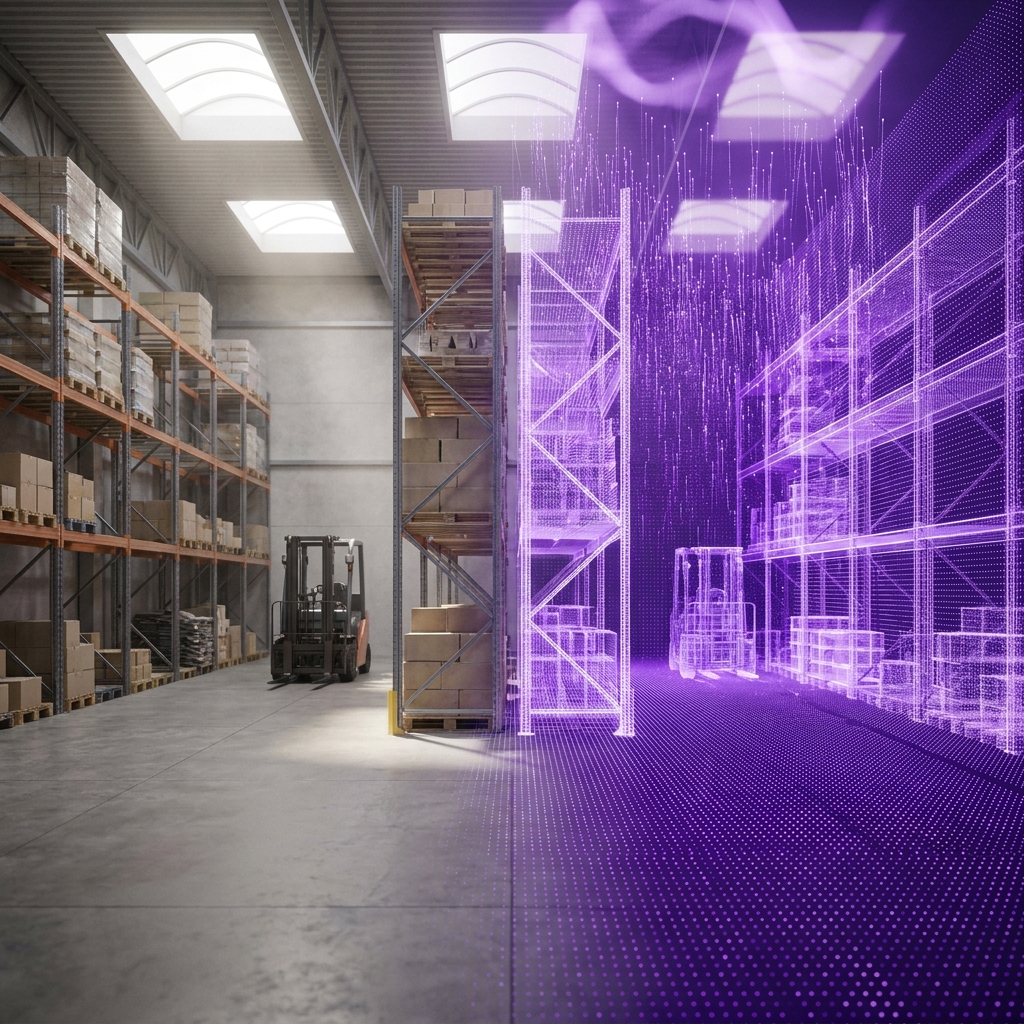
A 3D model / digital twin
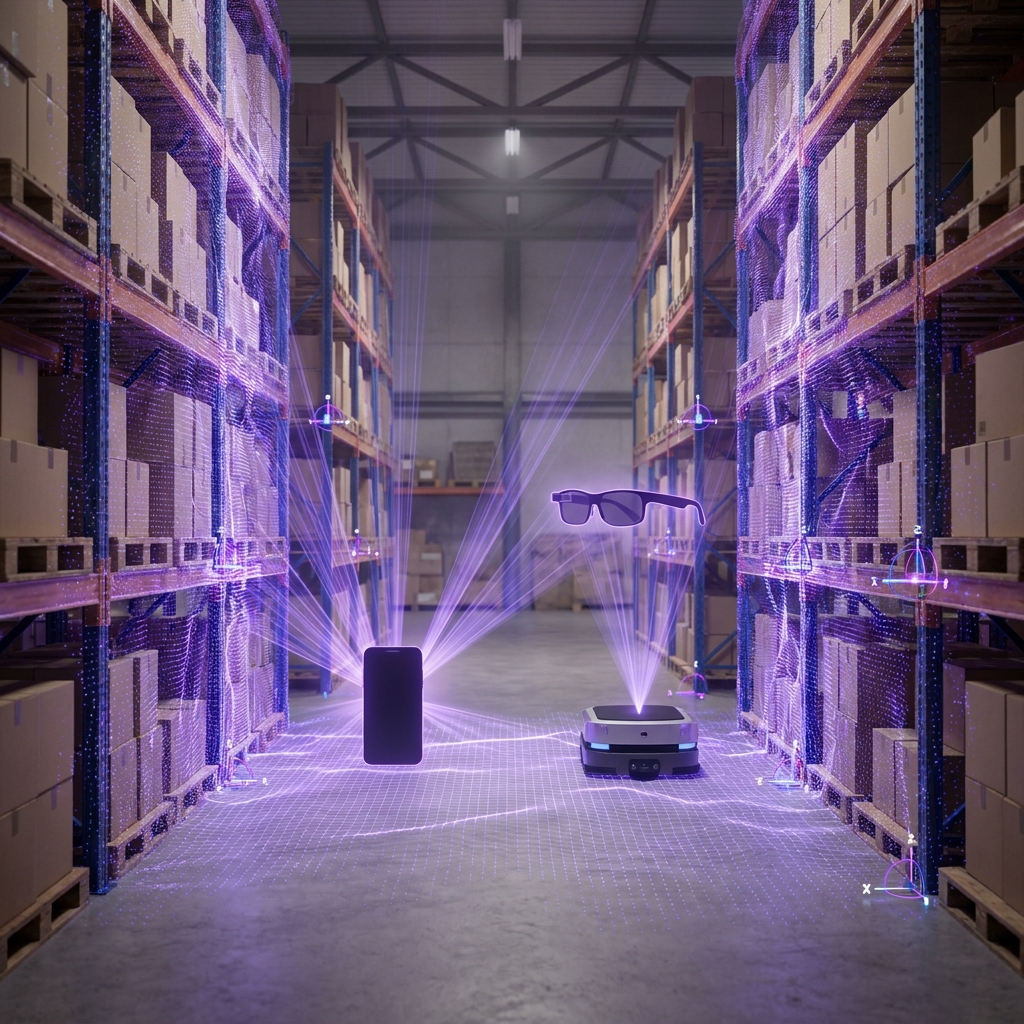
A MultiSet VPS map
What it produces
A viewable 3D model, mesh, or digital twin of the space
A 6-DoF localization map devices query for their exact position
Primary job
Document, visualize, measure, and plan the space
Position phones, headsets, robots, and agents in the space, live
Who consumes it
People reviewing the space on a screen
Devices on site, resolving where they are to centimeters
On site
Revisited later in a browser or viewer
Localizes on device in under 1500 ms, on-prem or offline
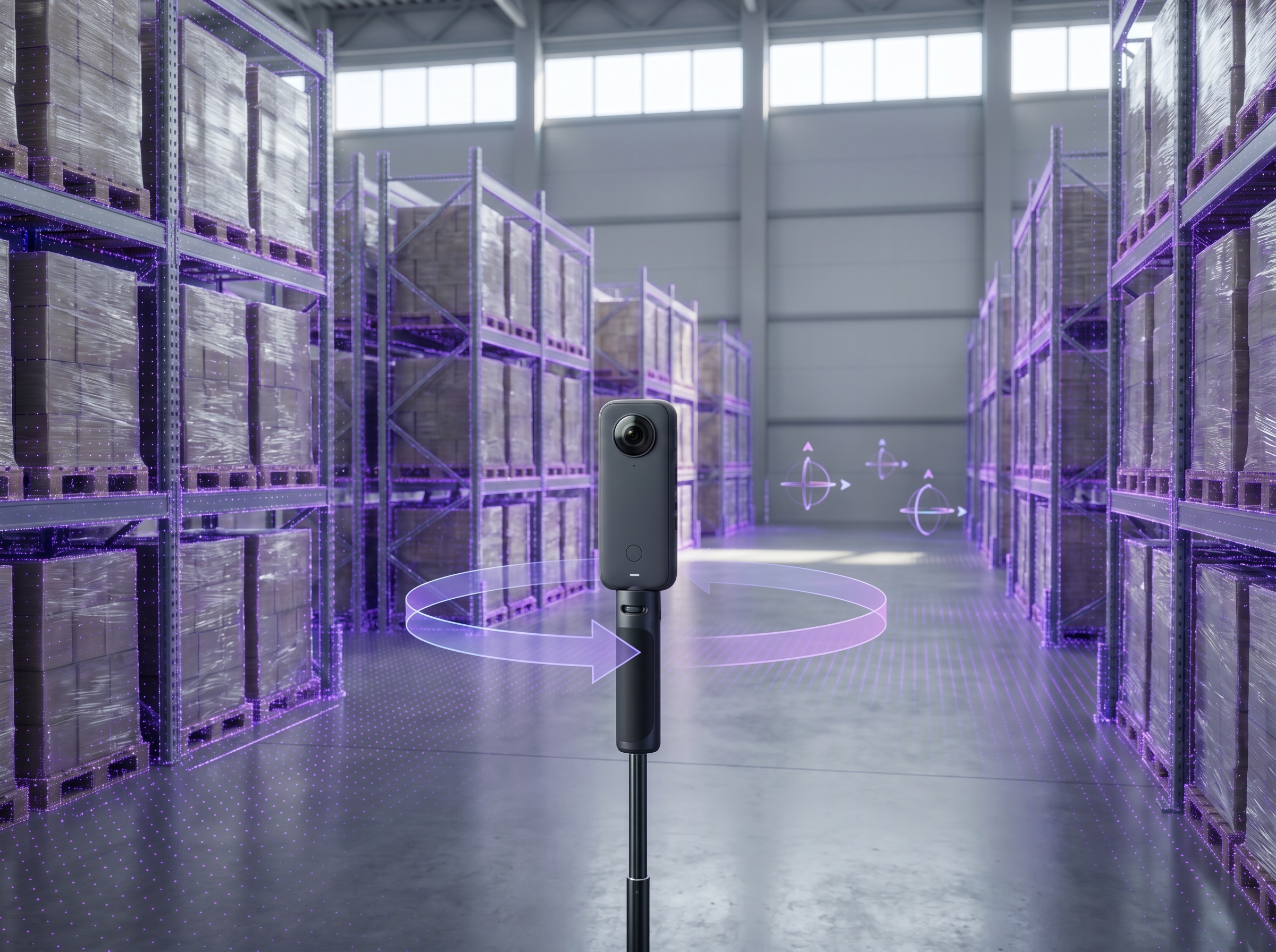
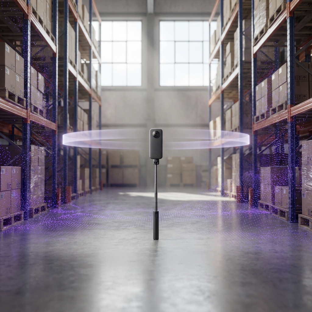
Capture sources
Often tied to one capture type or platform
Scan-agnostic: 360 video, E57, LiDAR, Matterport, and 3DGS in one map
Where it fits
Captures and documents reality
Makes that same reality queryable for AR, robotics, and spatial AI
Frequently asked questions
Can you turn a 360 video into a VPS map?

Yes. Upload a 360 video and MultiSet builds a VPS localization map from it. The result is a 6-DoF localization map your apps and robots query, not just a 3D model to look at.

Can I combine 360 maps with my E57, LiDAR, or Gaussian Splat scans?

Yes. MapSet stitches maps from different capture types into a single deployment and coordinate system. Mix 360, E57, LiDAR, and 3DGS across floors and buildings, and devices localize seamlessly across all of them.

How is this different from making a 3D model or point cloud from a 360 video?

A 3D model or point cloud is something you view and measure. A VPS map is something devices localize against. Phones, headsets, and robots resolve their exact position and orientation in the space, with 5 cm median accuracy.

Which 360 cameras are supported?

Insta360 X4 and X5 today. MultiSet is camera-agnostic by design, so more 360 cameras and capture workflows are added over time. Record in standard 360 video mode at 8K (recommended) or 5.7K, 30 fps.

Do I need to stitch or process the footage first?

No. Upload the raw video straight from the camera. Stitching and real-world scale are handled in MultiSet's pipeline, with no separate stitching tool or photogrammetry step in between.

How accurate is VPS from a 360 video?

5 cm median localization accuracy, with pose resolved in under 1500 ms. Accuracy holds in dynamic conditions, changing lighting, and spaces with people moving through them.

How large an area can one 360 capture cover?

As a guide, about 1,000 sq ft per 60 seconds of capture. For larger venues, record multiple walkthroughs and stitch them into one continuous map with MapSet. There is no ceiling on total coverage.